
The ES-Dive team includes engineers, dually registered Professional Engineer divers, and M.S.C.E.s with specialties in Hydraulic and Geotechnical Engineering.
Engineer-Diver Evaluation and Inspection Services
Underwater imaging and modeling
NBIS (National Bridge Inspection Standards)
Underwater (Level I, II, III)
Emergency (Impact & Scour Related)
Hydrographic Surveys
Remediation & Rehabilitation Design
Routine Topside
In-Depth & Fracture Critical
Non-Destructive Testing & Evaluations
Scour Evaluations
Underwater Imaging & Modeling
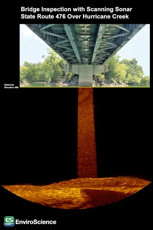
ES-Divers has been conducting underwater inspections since 1998 and is qualified in underwater imaging and modeling via side scan sonar and scanning sonar. Sonar (sound navigation and ranging) is a technology that utilizes sound waves to view underwater environments. Side scan sonar—usually mounted to or towed behind the boat—scans the river bottom. Scanning sonar remains stationary underwater and can scan 360 degrees. This technology is rapidly growing and developing—completely changing the way submerged settings are viewed and studied. With this technology, it is now possible to inspect submerged structures that were previously impossible due to hazardous or murky conditions. Bridge inspections, scour volume calculations, substrate mapping, survey-grade depth surveys, object location, search and recovery, diver safety, and more can be done efficiently and effectively.
ES-Divers has several divers, scientists, and GIS / CAD mapping analysts trained in sonar deployment and operations including sub-meter RTK technology. ES-Divers GIS analysts received in-depth training on the science behind acoustics and sonar technology, how to deploy and repair sonar hardware, and how to best process sonar imagery with multiple software packages. They have also been trained in the field for hands-on experience with the Mesotech 1000 Scanning Sonar, Starfish, and Dual Axis Scanning Sonar. ES-Divers used this technology to inspect bridge piers for the Tennessee Department of Transportation.
We offer:

Bridge profile and evaluation imaging
Acoustic Doppler current profiling
Starfish side-scan sonar
Substrate mapping
Large-scale thermal profiling
Sub-bottom profiling
Depth surveys (survey-grade equipment)
Multi- and single-beam sonar surveys
Sidescan sonar surveys
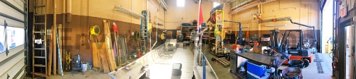
State-of-the-Art Equipment and Facilities

ES-Divers has a fleet of boats capable of performing in-shore and near-shore work across the country.
ES-Divers has the experience and extensive inhouse equipment to safely perform diving in harsh environments. Our diverse fleet of boats, multiple dive bays, and state-of-the-art dive equipment can be customized for many different marine applications. Our dive vessels are capable of performing in-shore and near-shore work across the country. Some of our dive vessels include:
Two 30’ Workboats
Two 24’ Workboats
One 21’ Workboat
Two 25’ Carolina Skiffs
Project Highlights
Underwater and Non-Destructive (NDT) Testing of Steel Bulkheads

ES-Divers perform underwater inspection, Non-destructive Testing, and Ultrasound Testing.
Level I, II, and III NDT
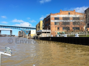
Cuyahoga River, Cleveland
ES-Divers has provided ongoing bulkhead services to Geis Companies. ES-Divers recently (2016) performed underwater non-destructive evaluation of 1500 LF of steel sheet pile bulkhead along the Cuyahoga River.
We completed comprehensive 100% Level I and 10% Level II underwater inspection of the entire length of the bulkhead. These Levels of inspection are based on the American Society of Civil Engineers (ASCE) Underwater Investigations Standard Practice Manual, 2001, United States Naval Engineering Command (NAVFAC), and the Federal Highway Administration (FHWA).
During the Level II inspections, the surface area was cleaned of marine growth at the waterline, mid-level, and at the streambed, and a hand held multiple echo ultrasonic thickness gauge was utilized to measure the remaining cross section of the steel sheet piling (Level III). We recorded water depth soundings along the length of structures and provide more detailed soundings if scour is discovered. Underwater digital photography was used to document conditions.
In addition to making sure our divers are well-trained, ES-Divers also invests in state-of-the-art technology and equipment to make sure our divers are safe and projects are completely efficiently.

Duck River, Marshall County, Tennessee
45 Underwater Bridge Inspections for Tennessee Department of Transportation
Locations across Tennessee
EnviroScience, Inc. (ES-Divers) performed underwater bridge inspections for the Tennessee Department of Transportation (TDOT), as a subconsultant to Palmer Engineering, following Federal Highway Administration (FHWA), Occupational Safety and Health Administration (OSHA), US Coast Guard (USCG), and TDOT regulations. ES-Divers was responsible for providing all necessary dive equipment and personnel to complete the underwater inspections. Water conditions consisted of zero visibility, swift current and heavy debris.
ES-Diver’s dive plan and method of operations was determined to maintain safety, communication, and efficiency for the inspection team. ES-Divers mobilized commercial dive teams with state-of-the-art surface-supplied-air (SSA) equipment, diving vessels, sounding equipment, and Sector Scan Sonar hardware and software to capture detailed underwater images. Our surface supplied air diving operations enabled the diver to be in constant communication with the surface support team throughout the entire inspection. All equipment and staff necessary to successfully complete the inspection was assessed prior to the inspection. Daily dive logs, hazard analysis, and safety briefing reviews were conducted prior to every dive. Our diving inspection teams are continually updated and trained in the changing environments and approaches related to the underwater inspection services offered.
Upon completion, all field notes and applicable sketches were verified against previously noted conditions. A report including notes, sketches, sounding data, pictures and recommendations was compiled for each of the inspected bridges. Underwater acoustic images of the substructure and surrounding streambed were acquired for bridges with water depths that exceed 33 feet. Our GIS specialist created a mosaic using images gathered in the field using a state-of-the art sector scan sonar head and software coupled with HD photographs.
Contact Us
Our experts are here to discuss your needs and how we can help you move your project forward. Fill out the form below for more information on our services or to request a quote and we’ll get back to you within 24 hours. If you need a response within an hour or less, call us at 800-940-4025.